AviationWX.org
An open source project for serving realtime aviation weather data.
aviation open source free weather METAR weathercam APIOverview
AviationWX.org is an open source project to bring weather webcams to airports for safety and awareness. The project provides real-time aviation weather data and webcam feeds for airports, making it easier for pilots to assess conditions before and during flights.
Motivation
As a pilot, I’ve found myself needing better visibility into airport conditions - both literally and figuratively. Traditional aviation weather sources provide METAR data, but seeing actual conditions with your own eyes can be invaluable. Weather webcams at airports are incredibly useful for flight planning, but they’re often scattered across different websites, hard to find, or simply don’t exist for many smaller airports. I’ve talked with a lot of small airport owners, and wanted to throw my hat in the ring to help out. If this helps save a single life, or helps someone feel more confidence in flying safely - it’s a win.
The motivation behind AviationWX.org was to create a free, open source solution that:
- “Feels like a PIREP from someone you trust at the field.”
- Aggregates weather data from multiple sources (Tempest Weather, Ambient Weather, Davis WeatherLink, or METAR)
- Makes it cheaper and easier to create safe, clean webcam feeds for airports of all sizes and budgets
- Use images whenever possible instead of live video streams to increase accessibility
- Displays real-time webcam feeds from airports
- Provides a clean, mobile-friendly interface that works well in the cockpit, from a tablet during planning, or from slow cellular internet on the side of a mountain strip
- Calculates aviation-specific metrics like density altitude, pressure altitude, and VFR/IFR/MVFR status
- Offers a free public API for developers to support integrating with their own airport websites
- Supports embeddable widgets that airports can add to their own websites
- Ensure the data collected is fed to NOAA and the FAA Webcam Project easily and in a normalized way
- In a world where increasingly everything is behind a paywall, safety should be free, or as cheap as possible
Inspiration - KSPB & 7S3
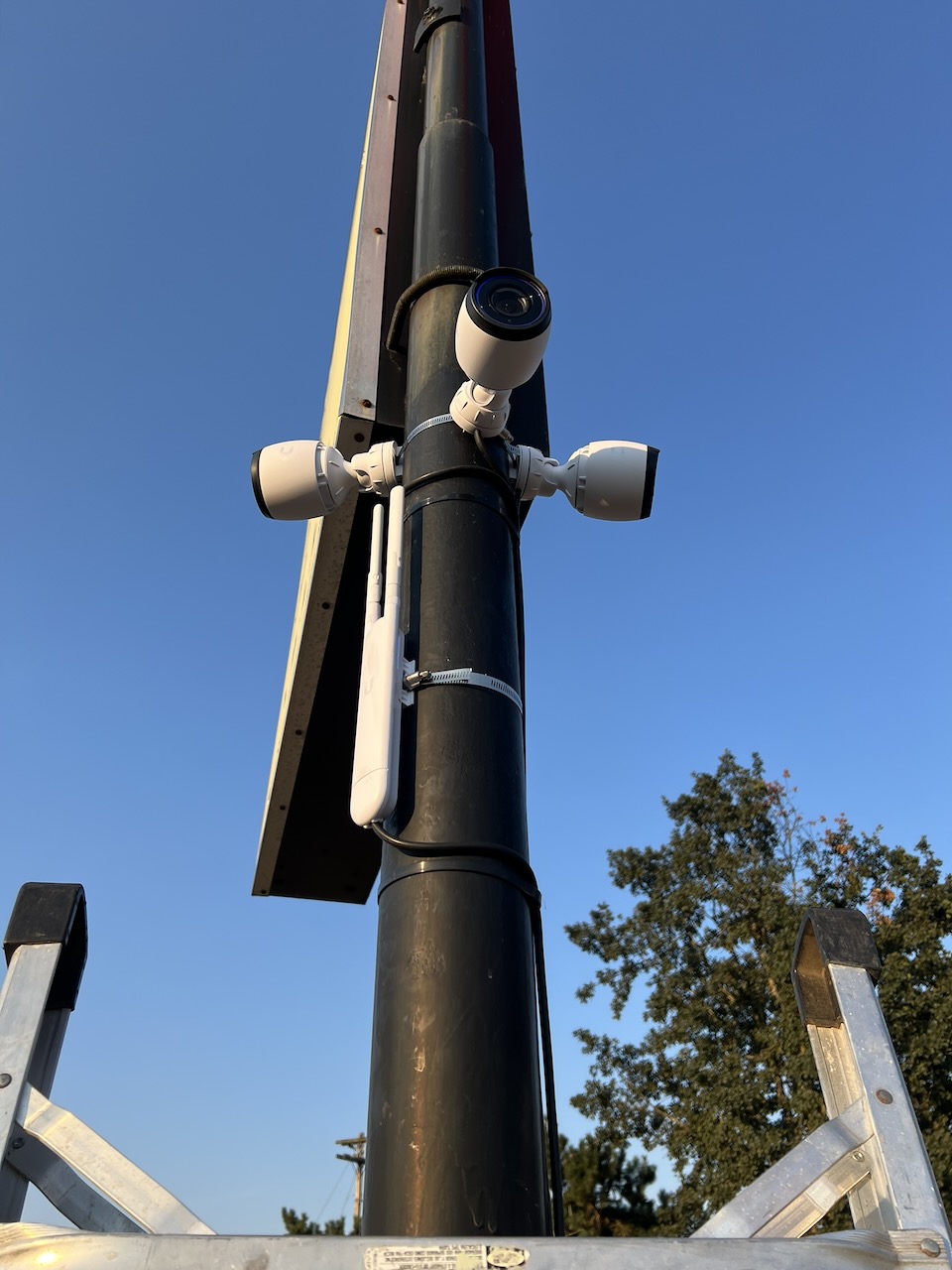
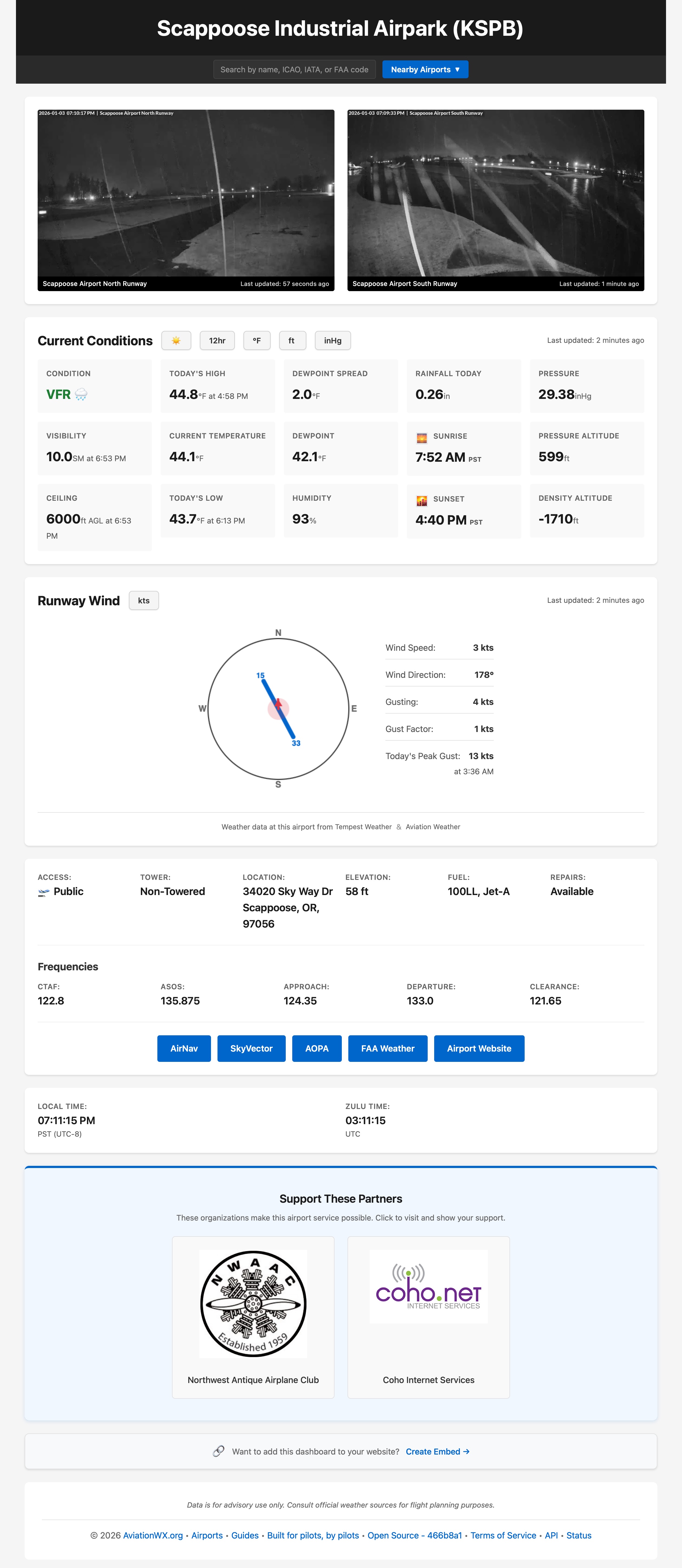
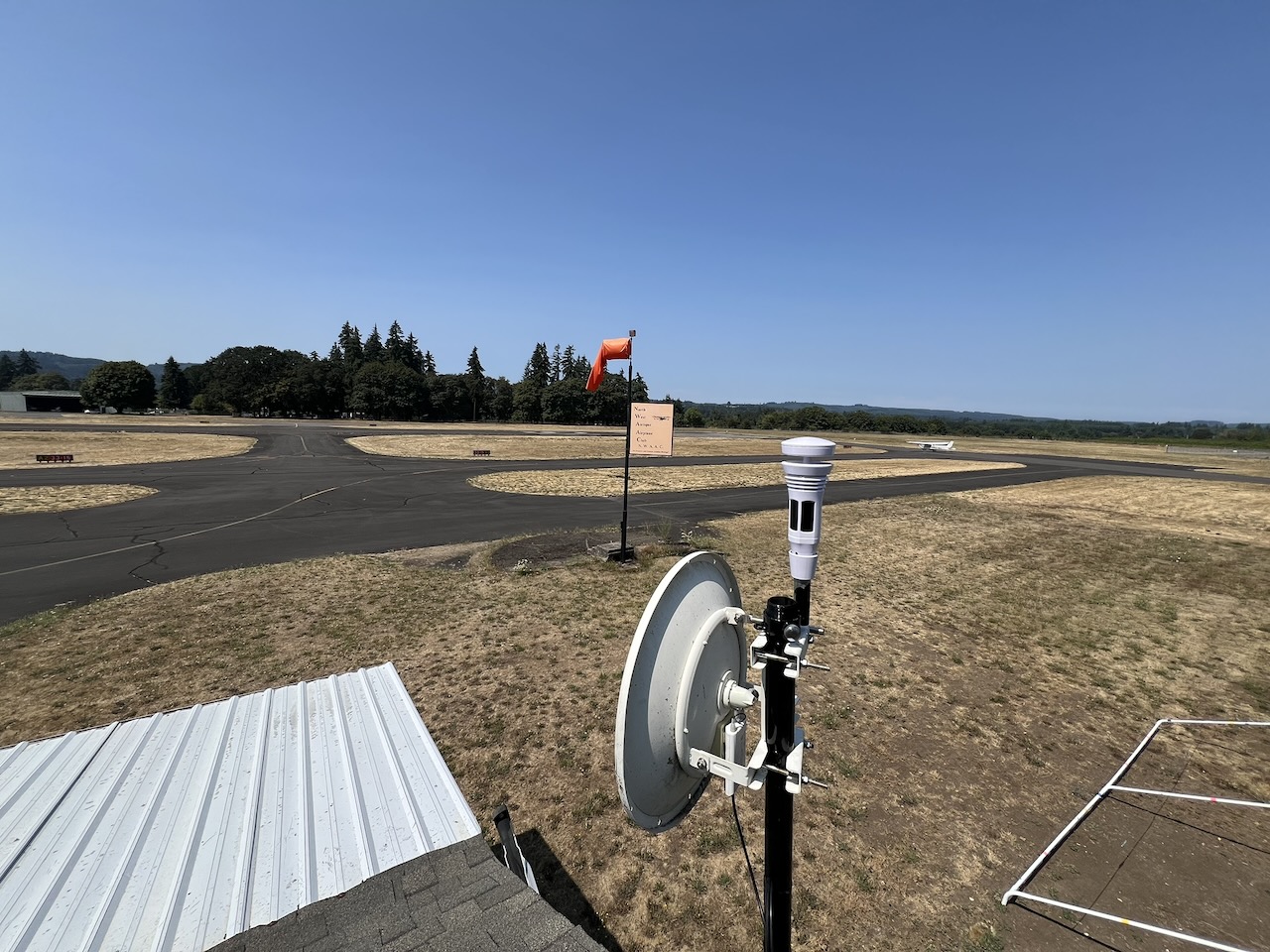
During 2023 KSPB had a METAR outage, combined with heavy flight traffic at a non-towered airport. It’s a great little field, but didn’t have a lot of nearby weather to lean on for wind, clouds, or other factors - especially while METAR was down for a few months. I worked to donate equipment, design and impliment a runway webcam system with partnership of a local WISP called coho.net and the club I was part of called NWAAC (Northwest Antique Airplane Club). After getting the hardware up, it quickly became clear that there wasn’t a great easy ready to go solution for displaying this data that was simple, clean, easy to maintain, and sustainable to run long term.
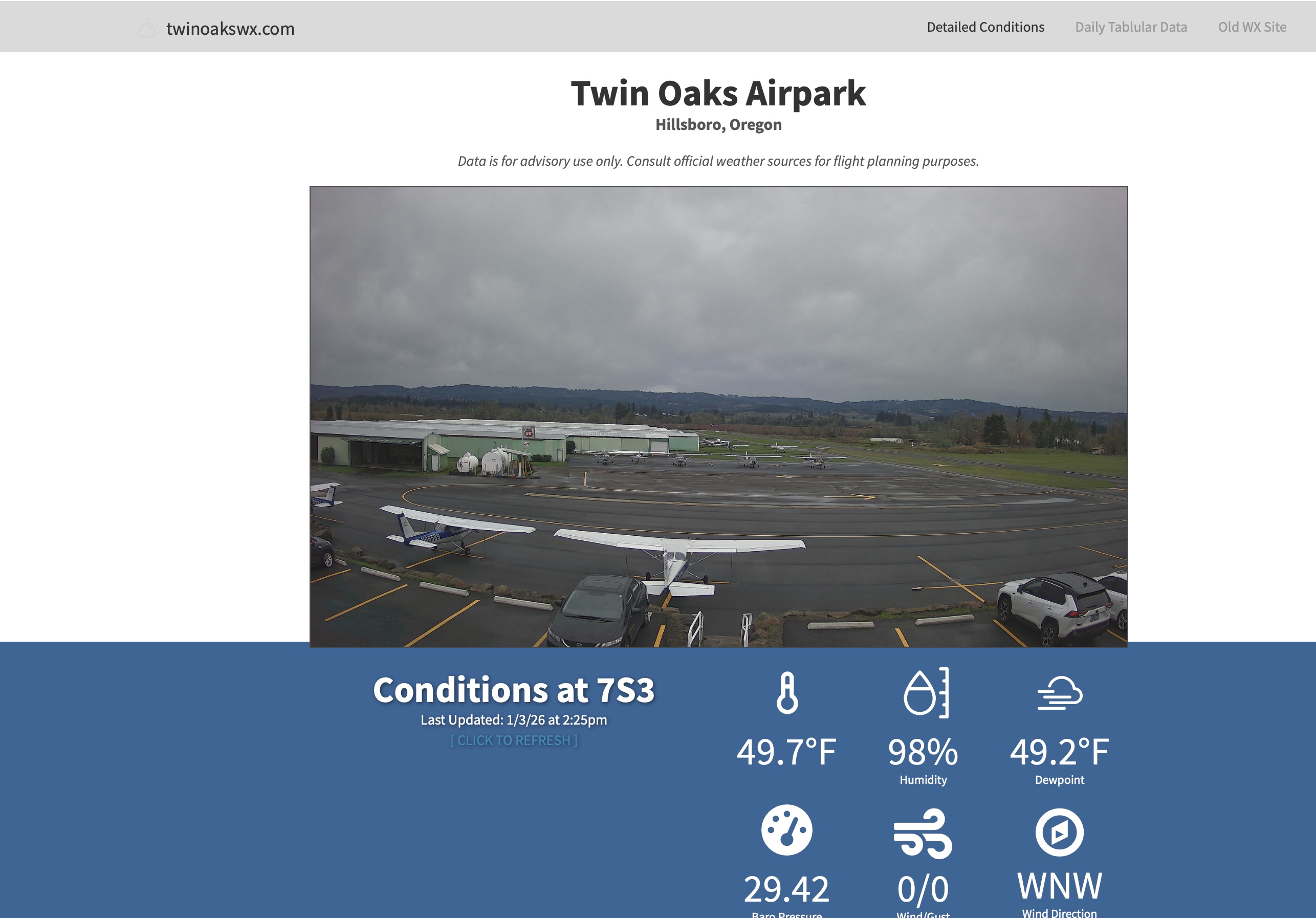
Well - I had been deeply inspired by http://www.twinoakswx.com which was a extremely valuable resource for me when I was based at Twin Oaks but drove to the hangar from Sandy, OR. I was always figuring out what the conditions were and if it was worth a trip to the hangar an hour each way, or if it would be safe to fly. The solution at Twin Oaks is minimal, elegant, cheap to operate, and amazing. - BUT - it wasn’t exactly an easy pattern to scale up to other airports, so I set out to create that solution.
GitHub Repositories
The AviationWX.org project consists of two main repositories:
AviationWX Main Repository
The primary repository contains the core application built with PHP, JavaScript, and includes features like:
- Weather data aggregation from multiple sources
- Webcam integration (static images, MJPEG streams, RTSP/RTSPS, and push uploads via SFTP/FTP/FTPS)
- Interactive wind visualization with runway diagrams
- Theme support (Auto, Day, Dark, and Night modes - including a red night vision mode for night time use)
- Embed generator for creating weather widgets
- Public REST API
- Mobile-first responsive design
Repository: github.com/alexwitherspoon/aviationwx
AviationWX Bridge
The supporting bridge repository handles data integration and processing between various weather sources and the main application.
Repository: github.com/alexwitherspoon/aviationwx-bridge
Features
Weather Data
The system supports multiple weather data sources and automatically handles stale data protection (nulls data older than 3 hours). It tracks daily highs and lows, peak gusts with timestamps, and calculates aviation-specific metrics like density altitude and flight rules.
Webcams
Webcam support is flexible - it handles static images, MJPEG streams, RTSP/RTSPS streams, and push uploads. The system includes automatic caching with background refresh, circuit breakers for failing sources, and optional time-lapse history with shareable URLs.
User Experience
The interface includes interactive runway wind diagrams, unit toggles (temperature, distance, wind speed, barometer), theme toggles that persist user preferences, weather status emojis for quick visual indicators, and offline support via service workers.
Embed Generator
Airports can create embeddable weather widgets in multiple styles (Mini Airport Card, Single Webcam, Dual Camera, 4 Camera Grid, Full Widget) that can be easily integrated into WordPress, Google Sites, Squarespace, or any HTML page. Visit embed.aviationwx.org to create your own.
Public API
AviationWX provides a free public API for developers. The API documentation is available at api.aviationwx.org with rate limits of 20 requests/minute for anonymous users and 120 requests/minute for partners with API keys.
Examples
For Pilots
Simply visit aviationwx.org and navigate to any supported airport (e.g., kspb.aviationwx.org for Scappoose Industrial Airpark). You’ll see real-time weather conditions, webcam feeds, and aviation-specific metrics all in one place. The night mode is particularly useful for cockpit use, with a red theme that preserves night vision.
For Airport Operators
Airport operators can participate in AviationWX.org for free! If you have weather station API credentials (Tempest, Ambient, or WeatherLink) and webcam information, email contact@aviationwx.org to get your airport added to the system.
Documentation and Resources
- Main Site: aviationwx.org
- Guides: guides.aviationwx.org
- API Documentation: api.aviationwx.org
- Embed Generator: embed.aviationwx.org
- Status Page: status.aviationwx.org
The project includes comprehensive documentation in the GitHub repository covering local development setup, testing, deployment, configuration, architecture, and contributing guidelines.
Contributing
As an open source project, contributions are welcome! Whether you’re fixing bugs, adding features, improving documentation, or helping to add more airports to the system, the aviation community benefits from collaborative development. See the contributing guidelines in the main repository for details on how to get started.